Greetings BRCWRT Members and
Friends - This edition of Preservation Corner provides
updates on the PW
Digital Gateway Comprehensive Plan Amendment (CPA)
in Prince William County (PWC) and related actions
that pose a threat to Manassas National
Battlefield Park, the development threat to Mt.
Zion Battlefield and Mt. Zion Historic Park, and
the Civil War Redoubt at Farr’s Cross Roads on
George Mason University’s Fairfax Campus.
Thank you for your continued
interest in, and support of, BRCWRT’s preservation
actions and activities. Blake Myers, BRCWRT
Preservation Chair
Preservation Corner
April 28,2022
Prince William
(PW) Digital Gateway
On July 20, 2021 the PW Board of
County Supervisors (BOCS) approved initiation of
Comprehensive Plan Amendment #CPA2021-0004, PW
Digital Gateway. The proposed amendment includes
changing the long- range land use designation
within the Pa Study Area from AE (Agricultural or
Estate) and ER (Environmental Resource) to T/F
(Technology/Flex) with a T-3 Transect. The
application included the proposed PW Digital
Gateway, a Pageland Lane Technology Corridor for
data center development. While this specific
application focused on data centers, a T/F land
use designation, would allow for other industrial
land uses as well, including warehouses,
distribution centers, etc.
%20Study%20Area%20.png)
Prince William Digital Gateway (CPA #2021-0004) Study Area
Two separate but related PW County actions, the Data Center Overlay District Zoning Text Amendment and the development of a new Comprehensive Plan (Pathway to 2040) potentially impact CPA2021-0004; however, the interconnectivity and information exchange between and among the three actions and processes is not clear or well understood.
In its latest action regarding the PW Digital Gateway, on April 7 & 8, 2022 the BRCWRT submitted letters to each of the PWC Supervisors, to each member of the PWC Planning Commission and to the PWC staff lead planners stating our significant concerns and our strong recommendation to not support the proposed PW Digital Gateway:
-
The Study Area and the proposed PW Digital Gateway is located on historic land directly adjacent to Manassas National Battlefield Park (MNBP) and poses a direct threat to the Park’s historic sites and to visitor viewsheds from these historic sites;
-
Much of the land in the Study Area, particularly in the southern portion, is within the Congressionally designated MNBP boundaries, or is designated by the American Battlefield Protection Program as Battlefield Core Area – historic land that should not be designated for industrial or high-density residential use;
o 10acresarewithintheCongressionallydesignatedMNBPboundary,butcurrentlynot within MNBP’s legislated boundaries;
o 107acresarewithintheAmericanBattlefieldProtectionProgram(ABPP)designated Manassas Battlefield Core Area, land which is eligible for incorporation into MNBP and where American soldiers camped, fought and died during the August 1862 Battle of 2nd Manassas;
-
The CPA applicant has stipulated a willingness to mitigate adverse impacts (visual, noise, lighting, etc.) that result from the proposed data centers; however, typical mitigation measures (setbacks, buffer areas, berms, tree screens, building and lighting restrictions, etc.) in practice have proven inadequate in effectively mitigating the adverse impacts of such industrial facilities on adjacent historical resources. Avoiding adverse impacts by not allowing data centers, or any other industrial development, on or adjacent to historic land is the preferred policy. Changing the land use designation of land that is on, or adjacent to, historic land and sites from AE and ER to T/F will lead to the very adverse impacts that are of such great concern;
-
Though proximate to the existing Dominion Energy transmission line along and paralleling Pageland Lane, that transmission line is “near or at capacity”. Any data centers, or other industrial use facilities, built in the Pageland Lane corridor north of U.S. Route 29 will require new power sub- stations and/or transmission lines to provide the requisite electric power – a situation that would significantly increase the adverse impacts on MNBP and its historic sites and viewsheds;
-
Any widening of Pageland Lane, including associated VDOT Rights of Way, would serve to intensify and magnify the adverse impacts of the proposed data centers.
Data Centers may be viable economic assets for Prince William County and there are certainly appropriate locations within the County for them; however, many of the land parcels in the Pageland Lane Corridor are not appropriate locations for data centers due to the land’s historic nature and the direct adverse impacts data centers would have on MNBP and its historic sites and viewsheds.
Readers of this column, and particularly those who are Prince William County residents, are strongly encouraged to let your voices and concerns be heard. Contact the PW Board of County Supervisors and/or your respective PWC District Supervisor and let them know your concerns with the proposed PW Digital Gateway and the negative impacts on historical sites and cultural resources that would result from approving the PW Digital Gateway.
Preservation Corner April
28,2022
Mt.
Zion Historic Park & Mt. Zion Battlefield
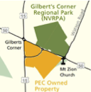
Located immediately south of, and
directly across Route 50 from, Gilbert's Corner
Regional Park in Aldie, Virginia, sits the Mt.
Zion Old School Baptist Church, constructed in
1851, and Mt. Zion Historic Park.
Mt. Zion Church was a place of worship for Old School Baptists until 1980 and experienced various uses during the Civil War, including a rendezvous point for Mosby’s Rangers, a hospital, a prison, and a battleground. The adjacent cemetery contains more than 240 marked graves, including those of Civil War soldiers and a War of 1812 veteran. On July 6, 1864 a skirmish and running fight pitted Union cavalry under Major William Forbes against Colonel John S. Mosby and his Rangers. Mosby’s Rangers, moving westward parallel to the Little River Turnpike (today’s Rt. 50) attacked Forbes’ men on grounds just east of the Skinner House (today a Buddhist Temple) routing and chasing them to Mt. Zion Church and south along the Old Carolina Road to Little River Church.
As initially reported in March 2020, a planned residential development potentially threatened the Mt. Zion Historic Park and the Battlefield. The Tanager Subdivision envisions 31 single-family homes and a 96-acre Open Space parcel bordering the Piedmont Environment Council (PEC) owned property and Mt. Historic Park. The BRCWRT continues to support the campaign to protect Mt. Zion as a member of the
Protect Mt Zion preservation group, led by the Ohana Preservation Foundation and including the Piedmont Environment Council (PEC)'
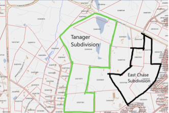
Tanager Subdivision Schematic
The Phase 1 Cultural Resources Report Summary, completed in May 2021, indicates that no above-ground features were identified, and no artifacts were recovered during the course of the archaeological investigation conducted between April 30 and May 6, 2020, June 9 and 11 2020, and May 11 and 13, 2021. The Tanager Subdivision Plan submitted in January 2022 proposes an historic setback, corresponding with a previously noted Parcel “A” Open Space along the property’s western boundary with the PEC and Mt. Zion Historic Park properties, that roughly aligns with the June 17, 1863 Battle of Aldie Study Area identified by the Civil War Sites Advisory Commission (see diagram, below).
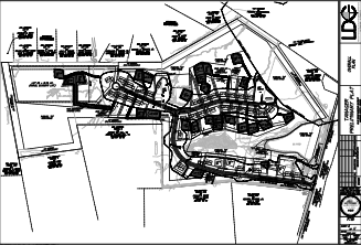
Tanager Subdivision Plan Diagram, January 2022
While the direct threat to the Mt. Zion Battlefield appears to have been resolved, the threat to the remnants of the Old Carolina Road remain. PEC notes in its April 2022 letter to the Loudoun County Department of Building and Development regarding the Tanager Plan that PEC and NOVA Parks (owner of Mt. Zion Historical Park) have collaborated to provide a publicly accessible walking path along their shared boundary that follows the remnants of the historical Old Carolina Road. PEC further notes that the remnants of the Old Carolina Road continue beyond the existing NOVA Parks/PEC walking path for some 670 feet along the property boundary of the PEC property and the Tanager property. PEC recommends consideration of an extension of the existing Old Carolina Road pathway along the PEC - Tanager property boundary, consistent with the County’s priority of creating interconnected linear parks and trails and to enhance the visitor experience.
The Parcel “A” Open Space, noted above and which includes portions of the Aldie Battlefield Study Area and the Old Carolina Road trail corridor, will likely be conveyed to an HOA for future maintenance, sustainment and management – appropriate management of these resources and access to the Old Carolina Road trail corridor would offer a significant amenity to future Tanager residents.
Preservation Corner April
28,2022
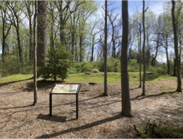
Civil War Redoubt at Farr’s Cross Roads
(GMU Fairfax Campus)
A dedication ceremony for the preserved and interpreted Civil War Redoubt at Farr’s Cross Roads historic site, previously anticipated as a component of GMU’s 50th Anniversary commemoration activities during the first week of April 2022, did not occur. GMU 50th Anniversary commemorative events that were discussed during the Fall and Winter of 2021 and envisioned to be conducted in the Spring of 2022 never materialized – therefore no site dedication ceremony was conducted.
That said, the BRCWRT has now been
given the lead role in planning, coordinating and
conducting (in conjunction with GMU) a dedication
ceremony to recognize the preservation and
interpretation of this historic site, and
celebrate the GMU-BRCWRT partnership that made it
happen.
 |
 |
The dedication ceremony is planned for the Fall of 2022 and our planning and coordination has already begun – the ceremony and celebration will happen! Stay tuned for future announcements pertaining to the date and time of the ceremony and for information on the ceremony, which will include a formal program, music by the 8th Green Machine Regiment Band and a site tour.
Thank you for your continued interest in, and support of, BRCWRT’s preservation actions and activities. Blake Myers, BRCWRT Preservation Chair